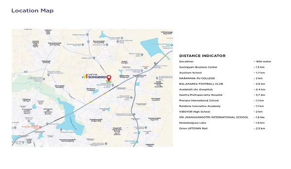
Sattva Songbird Map
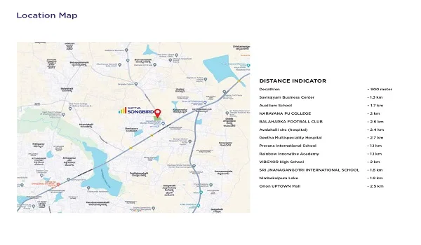
Sattva Songbird Map shows the exact location of the project on Budigere Road in East Bangalore. It shows the neighboring localities along with the nearest malls, hospitals, schools, and colleges. It helps everyone to get a clear idea about the project's neighborhood.
Find Sattva Songbird in Google Maps to reach the location with a Latitude of 13.049148224106593 and a Longitude of 77.74833982080948.
- North Schedule: Lands bearing Survey No.12 and Survey No.11
- South Schedule: Land bearing Survey No.17
- East Schedule: Land bearing Survey No.11 and Road
- West Schedule: Land bearing Survey No.15
Sattva Songbird is in the Bengaluru Urban District in Bengaluru East Taluk, and the pin code is 560049. The nearest airport, metro stations, bus stands, and railway stations are shown. There is good road access through
- NH 75
- SH 104
- Whitefield Main Road
- SH 35
- ORR
- OMR
- NH 44
By looking at the map, everyone can easily locate the project. The map shows the exact location of Sattva Songbird, and buyers can easily reach their dream homes with the help of it. The project is in a prime area with all the needed features at a nearby distance,
- Whitefield Bus Stop – 12.4 km
- Whitefield Metro Station – 9.8 km
- Kadugodi Railway Station – 9.1 km
- Kempegowda airport – 23.9 km
- Budigere lake – 10.2 km
The map shows the nearby schools, malls, colleges, and work areas,
- SAP Labs – 14.7 km
- EGL – 21.2 km
- TESCO – 13.5 km
- ITPL – 11.4 km
- Wipro – 26.5 km
- Brigade Tech Park – 11.2 km
- EPIP Zone – 14.9 km
- GR Tech Park – 10.6 km
Schools nearby
- Orchid School – 21.1 km
- Vagdevi Vilas School – 20.5 km
- National Public School – 16.8 km
- VIBGYOR High School – 2.7 km
- MVJ School – 20.2 km
- DPS East – 26.2 km
Hospitals nearby
- Kauvery Hospital – 16.9 km
- Manipal Hospital – 20.1 km
- Svastha Hospital – 12.1 km
- Motherhood Clinic – 4.8 km
- M.G.A Hospital – 19.1 km
- Hope Hospital – 9.4 km
Shopping Center nearby
- Phoenix Market City – 13.7 km
- Orion Mall – 32.6 km
- Inorbit Mall – 13.1 km
- VR Mall – 14.1 km
- Park Square Mall – 11.5 km
The project has a good social infrastructure, and buyers will never regret buying a dream home in this location. The map gives a visual picture of the nearby areas of the project. It also shows the exact location and complete details about the surrounding features.
| Call | Enquiry |
|
